Albany Creek Road — the suburb's main artery, lined with the shops, schools, and services that make this one of Brisbane's most self-contained family suburbs. The name 'Albany Creek' was adopted in 1885 after locals petitioned to change it from 'Chinaman's Creek' — a name that stuck even though no Chinese people ever lived in the area.
James Cash's Hut (1849)
The story of Albany Creek starts with James Cash, the first permanent European settler in the area. In 1849 — just seven years after Brisbane was declared a free settlement — he built a hut near the South Pine River, on the northern fringe of the expanding colony. His name is still on the map today: Cash's Crossing, where South Pine Road meets the river, is one of those landmarks that Brisbanites use without thinking about who Cash was or why he mattered.
The crossing wasn't bridged until 1934, when the original Cash's Crossing Bridge opened, connecting the growing northern settlements to Brisbane. Before that, travellers forded the river — a risky proposition when the South Pine was in flood.
Farm selections were taken up through the 1860s. The first industries were timber cutting — the surrounding bush was rich with hardwood — followed by mixed farming and eventually dairying, which became the principal occupation for the next century.
Chinaman's Creek (1874–1885)
The creek that gave the suburb its first name ran through the district. Locally, it was known as Chinaman's Creek — a name common in colonial Australia, usually referencing market gardens or mining camps. Except in this case, the name was entirely inaccurate: no Chinese people ever lived or worked along the creek. The name just stuck because that's what everyone called it.
In 1874, the Chinamans Creek Primary School opened — the first public building in the area. (Today it's Albany Creek State School, one of the oldest continuously operating schools in the Moreton Bay region.) A Methodist church had been built around 1866. A village store opened in about 1905. The cemetery — established 1873 — holds the graves of the pioneer families who built the district.
In 1885, local petitioners finally had enough. They asked the colonial government to change the name, pointing out that no 'Chinaman' lived there. They chose Albany Creek — the records say for 'sentimental reasons.' The new name stuck, and Chinaman's Creek faded into the kind of footnote that only local historians remember.
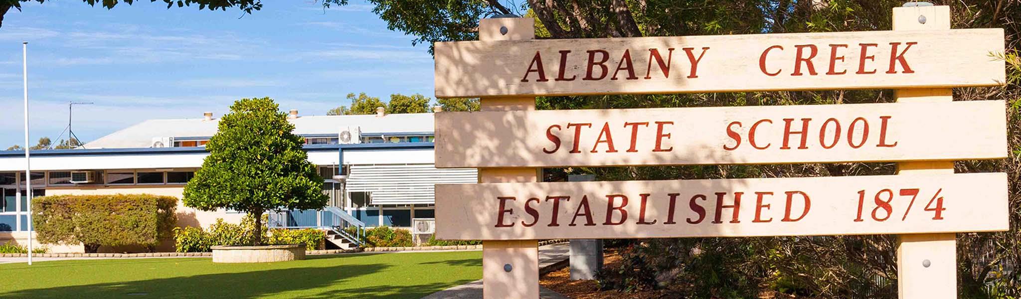
Albany Creek State School — opened in 1874 as Chinamans Creek Primary School, one of the oldest continuously operating schools in the Moreton Bay region. The name changed when the suburb did, but the school's heritage runs deep. Today it serves a community that values education as one of its core pillars.
The Village That Slept for a Century (1900–1960)
For the next sixty years, Albany Creek barely changed. The 1911 census counted just 90 people. By 1966, it had crept to 235. This was dairying country — quiet, rural, and deeply settled. Families worked the same land their grandparents had taken up in the 1860s. The creek, the river crossings, the church, and the school were the fixed points around which everything revolved.
Then Brisbane started growing north.
The Boom Decades (1970–2000)
In the 1960s, the metropolitan expansion that had already swallowed Stafford, Aspley, and Chermside reached the South Pine River. Albany Creek's population exploded:
1966: 235 people
1971: 1,523 — six times larger in five years
1981: 4,394 — another tripling
1991: 8,537 — doubled again
2001: 14,992 — nearly 15,000 people, up from 235 in 35 years
A State high school opened in 1982 — now one of the largest in the Moreton Bay region. A sub-regional shopping centre opened on Albany Creek Road in 1988. Albany Hills State School opened in 1979 to handle the overflowing enrolments. A Catholic primary school followed in 1989.
Albany Creek Today — Stable, Settled, Sorted
Albany Creek in 2026 is home to about 16,400 people, 17km from the CBD. The median house price is $980,000 — up 58% in five years, which sounds like a lot until you compare it to Stafford's 88% or Everton Park's 80%. The stability is the feature, not the bug.
The owner-occupier rate of 65% tells the story: this is a suburb where people buy and stay. The median age of 40 reflects a mature family demographic — not the young renters of Mango Hill, not the empty-nesters of Sandgate, but families firmly in the middle of their lives.
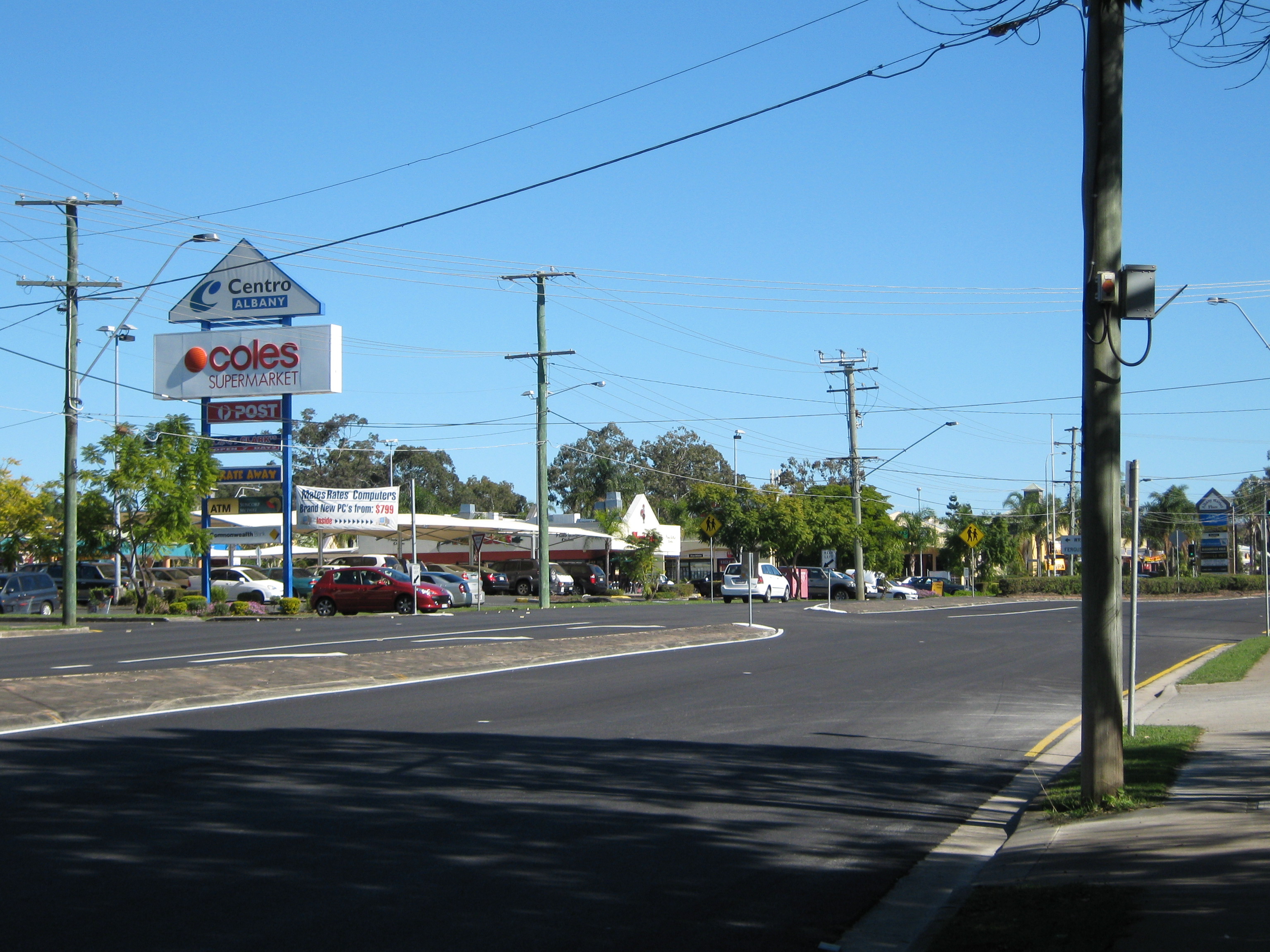
Wolter Park is the sporting heart — home to one of Brisbane's largest soccer clubs. The South Pine River provides a green corridor with linear parks and walking trails. The Albany Creek shopping villages on Albany Creek Road and Old Northern Road handle daily needs, while Westfield Chermside and North Lakes are both within 15 minutes.
Who Should Buy Here?
Albany Creek is for families who want stability over spectacle. It's not the suburb with the highest growth or the trendiest cafes or the most dramatic origin story. It's the suburb where you buy the house, enrol the kids at the school that's been there since 1874, join the soccer club, and realise ten years later that you never had a reason to leave.
It's named after a creek that was given the wrong name by people who couldn't be bothered to fact-check — and then renamed for 'sentimental reasons.' That sentimental streak is still there. You can feel it in the streets, in the parks, in the way the population barely moves because nobody wants to be the one who leaves.
And if you stand at Cash's Crossing and look at the river, you can still imagine James Cash's hut, the 1849 frontier, and the beginning of a suburb that would take 120 years to wake up — and hasn't stopped running since.